Video 2
Friday, January 26, 2007
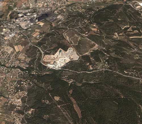
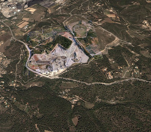
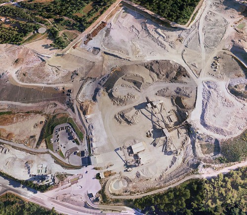
Pict'Earth images for Google Earth. Results.
We public and place Network link to dataset in BBS forum.
Full images collection see http://www.flickr.com/photos/valery35/sets/72157594386604591/
Example of large large image (4800 x 4182) with premium quality http://www.flickr.com/photo_zoom.gne?id=368176133&size=o
Generation of tiled images and network links we make with Superoverlay.
Tuesday, January 23, 2007
Pict'Earth : Images for Google Earth "On Demand"

If you look at the FAQ from Google Earth website the first questions are :
- How old are the images, How often are they updated ?
- Are they captured real time ?
- Why is there no sharp images over my house ?
Even if these questions may seem a little bit basic, they show very well the expectations of GE users. Once you have surfed the Grand Canyon, New York and Paris you want to know if the image of places where you live, where you work look like "reality". And of course most of the time you will not see your new car parked in front of the house or maybe not even the house itself. And now for the user these few hundred square meters or hectars have much more value than the nice image of Central Park. How relevent is an information if it is not sharp and fresh ? What is the value of a data if it does not cover your field of interest?
First involved in providing GIS professionals images for technical use we have created tools to guide us on our missions out on the field to shoot the images correctly and help to process them rapidly. As we use live image and gps transmission between the aircraft and the ground we have all it takes to find out the print of each image. Turn this to kml and there you are...
So now, no you will not be able to update the Grand Canyon image, but you will have a good start to answer our first 3 questions :
- How old are the images, How often are they updated ? The image is 20 minutes old and can be updated in 1 houre, 1 day, 1 month...
- Are they captured real time ? You would not do better with your camera
- Why is there no sharp images over my house ? Is 5 cm sharp enough?
Sunday, January 21, 2007
Real time Hi-res Images for Google Earth

Frank Taylor (Google Earth blog) place very nice information about new technology of data mining.
http://www.gearthblog.com/blog/archives/2007/01/watch_remote_control.html#comments
For this and near technologies we make program Superoverlay
Full text and comment by David Riallant
GEarth blog.
===============
Watch Remote Control Plane with Camera Capturing Real-time Images for Google Earth
Check out this really cool video showing a guy launching a small unmanned remote control aerial vehicle with a digital camera used to capture images and then show the images in Google Earth.
Video 1
Video 2
The company Pict'Earth , has released these videos on their web site. The guy can view the images in real-time with VR goggles. Later, the images can be shown in Google Earth. This has got to be one of the cooler things I've seen done with Google Earth! And, there are some real practical uses of this technology. Google should take note. This technology could be a much less expensive way to acquire very-high-res data for certain situations - particularly for special events.
===========
Full text of comment by David Riallant
----------------------
From Pict'Earth staff
Hello we have been working on Pict'Earth for more than a year now.
First of all to answer technical questions : there is one video camera (low res) with images streamed down real time to the ground. This is what we use for live update. But a digital camera shoots 7 - 9 megapix images at the same time. In post process we get images from the camera. With these images we can go as low as 3 cm resolution.
Second point : we get a very good mosaic but for fine results images can be post processed. This has been our job for the past 5 years so we know what we are doing...
We can provide the full packaged solution : from the UAVs to the video goggles, software, fine correction services... to meet your exact needs.
We have worked so far on many applications : agriculture, archeology, indistrial areas, road surveillance...
If you have to fly bigger areas, we also offer a regular plane platform but often projects fit into the UAVs possibilities.
It is true that satellites do incredible job with very fine res, on big areas. But our idea is : how worth is the information if it is not fresh, if you do not control the source? Do you buy last month's news paper? How do you do if you need a regular update on a specific high value area? Do you buy a full Ikonos every week? This is where we stand : provide high temporal and spatial resolution on specific areas of interest.
All your critics, suggestions and projects are welcome.
------------------
I see in this publications good sign. GIS it is not software, geodatabases and projects only. GIS it is engine for next ideas and technologies.
We (i and David Riallant) began now partnership.
We have ideas make professional solution on base of Pict'Earth hardware system and new Pict'Earth software system.
Images in this post it is first results of Superoverlay generation gataset by Pict'Earth.
Network link to superoverlay.
Load and double click Network link please.
Subscribe to:
Comments (Atom)


